
There are about 406 islands in Denmark, not including the Faroe Islands or Greenland. Some 70 of them are populated but the remainder are uninhabited. Some of the uninhabited islands have only become uninhabited in recent decades, for economic reasons.
DEFINITION
Different lists of Danish islands vary, depending on how the word "island" is defined. According to the official Danish Government definition, an "island" needs to be surrounded by water at least one-half metre deep and also have land vegetation growing on it to be recorded as such.
Another common criterion is that an "island" needs to be surrounded by free-flowing, natural water and not just an artificial, narrow canal. According to this criterion, places such as Christianshavn and Holmen in Copenhagen, although sometimes referred to as artificial islands, are actually parts of the island of Amager.
DYNAMIC NUMBER
The number of islands in Denmark changes from time to time. New islands are occasionally formed by sedimentation. Several examples of these new islands are found in the waters around Æbelø, north of Funen, including Drætlingen which formed in the late 1990s, and a still unnamed islet that was registered in 2008. These new islands are generally less stable than larger, morainic islands, and may later disappear again. Other islands are created artificially. Peberholm, formed in the process of construction of the Øresund Bridge, is a notable example. Other artificial Danish islands include a number of marine fortresses off Copenhagen, such as Middelgrundsfortet, Trekroner Fort and Flakfortet.
Islands may also disappear. An example of this is Jordsand, one of the Danish Wadden Sea Islands. According to records from 1231, the island then had an area of about 2,000 hectares (8 square miles). After a series of severe storms during that century, its area decreased to around 41 hectares, and by 1763 to around 18 hectares. By December 1999, the European windstorm Cyclone Anatol had destroyed the last piece of the island and Jordsand had ceased to exist.
FUNEN

Funen, with an area of 3,099.7 square kilometres (1,196.8 sq mi), is the third-largest island of Denmark, after Zealand and Vendsyssel-Thy. It is the 165th largest island in the world. It is in the central part of the country and has a population of 466,284 (2013). The main city is Odense which is connected to the sea by a seldom-used canal. The city's shipyard, Odense Steel Shipyard, has been relocated outside Odense proper. Funen belongs administratively to the Region of Southern Denmark. From 1970 to 2006 the island formed the biggest part of Funen County, which also included the islands of Langeland, Ærø, Tåsinge, and a number of smaller islands.
Funen is linked to Zealand, Denmark's largest island, by the Great Belt Bridge which carries both trains and cars. The bridge is in reality three bridges; low road and rail bridges connect Funen to the small island of Sprogø in the middle of the Great Belt, and a long road suspension bridge (the second longest in the world at the time of opening) connects Funen the rest of the way to Zealand, paralleled by a rail tunnel.
Two bridges connect Funen to the Danish mainland, Jutland. The Old Little Belt Bridge was constructed in the 1930s shortly before World War II for both cars and trains. The New Little Belt Bridge, a suspension bridge, was constructed in the 1970s and is used for cars only.
Apart from the main city, Odense, all major towns are located in coastal areas. Beginning in the north-east of the island and moving clockwise, they are Kerteminde (NE), Nyborg (E), Svendborg (S), Fåborg (SW), Assens (W), Middelfart (NW) and Bogense (N).
The populations of the major cities and towns are:
Odense, Svendborg, Nyborg, Middelfart, Fåborg, Assens, Kerteminde, Ringe, Bogense.
Funen was the birthplace of Hans Christian Andersen, the composer Carl Nielsen and American Revolutionary War hero Colonel Christian Febiger.
The highest natural point on Funen is Frøbjerg Bavnehøj.
FALSTER

Falster is an island in south-eastern Denmark with an area of 486.2 km2 (187.7 sq mi) and 43,398 inhabitants as of 1 January 2010. Located in the Baltic sea, it is part of Region Sjælland (County of Zealand) and is administered by Guldborgsund Municipality. Falster includes Denmark's southernmost point, Gedser Odde, near Gedser.
The largest town is Nykøbing Falster with over 40% of the island's inhabitants. Other towns include Stubbekøbing, Nørre Alslev and Gedser.
Falster is connected to the larger island of Zealand to the north by the Farø Bridges (Farøbroerne) on European route E47 linking Copenhagen to Hamburg and the south. To the south-west, the E47 connects Falster to the island of Lolland via a tunnel under the Guldborgsund strait. The Farø bridges join on the small island of Farø, and from there a further bridge gives access to the eastern neighbouring island of Møn.
There are two other bridges connecting to Lolland: the Guldborgsund Bridge at the northern end of the strait and the Frederick IX Bridge at Nykøbing Falster.
History
From medieval times until 1766, most of Falster belonged to the crown. King Valdemar's Census Book from c. 1231 lists all the parishes and most of the villages. Falster's two main towns, Nykøbing and Stubbekøbing, were both founded towards the end of the 12th century.
In medieval times, the island was marked by wars with the Wends in 1158 and with Lübeck in 1253. The census of 1509 includes only 90 of the 110 villages mentioned earlier. By contrast, it mentions 29 new settlements mainly along the coast.
In the 16th century, Falster had a number of farms which were owned by the local nobility but, from 1560 to 1630, they were slowly returned to the crown which once again owned the entire island. Therefore, Falster could therefore be used as the dowry for Frederick III's wife, Sophie Amalie but as a result of the high taxes which resulted, many of the farms were deserted.
Falster was managed as a crown estate from 1718 until 1766 when it was sold by auction and divided up into ten large farms, five of which were given large new fields. But as the fields had to be prepared through the serfdom of local peasants, this led to many disputes.
The villages were replaced by the community from 1778 to 1814, and gradually moved to freehold tenants, a process which was only completed in about 1860.
Falster experienced significant economic expansion after 1880 when, with the establishment of cooperative dairies and slaughterhouses, farming was concentrated on livestock production and forage crops. There was also an increase in the cultivation of sugar beet which was processed in factories at Nykøbing and Stubbekøbing between 1890 and 1914. Many seasonal workers, especially women, from Sweden and Poland came to help with harvesting the sugar beet and some of them stayed.
With the new railway from Orehoved to Nykøbing in 1872 and railway ferries to Masnedø (1884) and Warnemünde (1903), Falster slowly became a traffic hub. Its position was reinforced by the construction of the Storstrøm Bridge (1937) and Farø Bridges (1985).
Since 1975, Falster has been marked by high unemployment as a result of harder times for both farming and industry.
Towns and villages
Nykøbing Falster, Nørre Alslev, Stubbekøbing, Nordbyen, Væggerløse, Idestrup, Eskilstrup, Gedser, Marielyst, Horbelev, Orehoved, Ønslev, Systofte Skovby, Sønder Vedby Skovhuse, Horreby, Nykøbing Strandhuse, Øster Kippinge, Hasselø Plantage, Tingsted.
Tourism
With its marinas, sandy beaches and cycle tracks, Falster attracts tourists who wish to have relaxing holidays in unspoilt surroundings. One of the most popular resorts is Marielyst on the east coast.
Nykøbing offers a number of attractions including its old-town atmosphere with narrow streets. Of particular interest are the Middle Ages Centre, which is an open-air museum build as a part of a medieval town around year 1400 and the biggest attraction of the town. Among other attractions in Nykøbing are the Abbey Church (Klosterkirke) which was built in the 15th century, a City Museum and a zoo.
Scattered around the island are several minor museum such as Danish Tractor Museum and Crocodile Zoo in Eskilstrup, a motorbike and radio Museum in Stubbekøbing and a geological museum in Gedser, which holds the worlds largest polished garnet by the name of "Nordstjernen" (the Northern Star).
Transport
Falster has a motorway and trunk roads linking its towns and villages.
Nykøbing Falster's railway station is operated by Danish State Railways. There are regular passenger train services to Copenhagen via Ringsted. International trains operating between Copenhagen and Hamburg (via the train ferry between Rødby and Puttgarden) also call at the station. The Lollandsbanen operates a rail service to Nakskov.
There are also frequent bus services linking Nykøbing with other towns and villages on the island as well as with destinations on Lolland, Møn and Zealand.
LOLLAND
Lolland, formerly spelled Laaland, literally "low land") is the fourth largest island of Denmark, with an area of 1,243 km2 (480 sq mi). Located in the Baltic Sea, it is part of Region Sjælland (Region Zealand). As of 1 January 2013, it has 62,578 inhabitants.
Overview
Lolland is also known as the "pancake island" because of its flatness: the highest point of the entire island is 25 m (82 ft) above sea level, just outside the village of Horslunde. The island has been an important communication highway, among others for Nazi Germany during World War II. Historically, sugar beet has been grown in Lolland. Sugar is still a major industry, visible from the large number of sugar beet fields.
The largest town of Lolland is Nakskov, with 15,500 residents. Other main towns are Maribo (6,000 residents), which hosts the seat of the Diocese of Lolland and Falster, Sakskøbing (3,500 residents) and Rødby (2,500 residents).
The governments of Denmark and Germany plan to connect Lolland with the German island Fehmarn, by a future Fehmarn Belt Fixed Link. Route E47 from Copenhagen crosses the Guldborgsund strait between Lolland and Falster via a modern tunnel, but the motorway currently terminates at Rødbyhavn where a ferry carries vehicles to Fehmarn. Two older bridges also span the strait between Lolland and Falster, the Frederick IX Bridge and Guldborgsund Bridge at the northern end of the strait. Falster is directly to the east of Lolland.
Since January 1, 2007, Lolland has been administered by two municipalities, Lolland covering the western two thirds, and Guldborgsund uniting the eastern third with the neighbouring island Falster.
Towns and villages
Nakskov, Maribo Sakskøbing, Sundby, Rødby, Rødbyhavn, Søllested, Holeby, Nysted, Bandholm, Horslunde, Toreby, Guldborg, Kettinge, Nørreballe, Nagelsti, Stokkemarke, Dannemare, Hunseby, Sandby, Grænge, Langø- Lolland, Errindlev, Hillested, Ullerslev, Frejlev, Branderslev, Radsted.
Attractions
Among the attractions of the island are Fuglsang Manor built in the second half of the 19th century, and the neighbouring Fuglsang Art Museum which opened in 2008. Knuthenborg Safari Park north of Maribo is the largest safari park in Northern Europe and the holiday resort Lalandia is a giant indoor water-fun-land. Furthermore, Middelaldercentret is an open-air museum on the most eastern part of the island just outside Nykøbing Falster. The Centre is an experimental living history museum and it contains a reconstructed part of a medieval town from around 1400. It is among the most authentic reconstructions of the medieval period in Europe, and holds both the largest and the oldest trebuchets in the world.
Lolland has many sandy beaches and areas with summer houses, which are primarily visited by German tourists.
MØN

Møn is an island in south-eastern Denmark. Until 1 January 2007, it was a municipality in its own right but it is now part of the municipality of Vordingborg, after merging with the former municipalities of Langebæk, Præstø, and Vordingborg. This has created a municipality with an area of 615 km2 (237 sq mi) and a total population of 46,307 (2005). It belongs to the Region Sjælland ("Zealand Region"). Møn is one of Denmark's most popular destinations for tourists with its white chalk cliffs, countryside, sandy beaches and the market town of Stege.
Location
Møn is located just off the south-eastern tip of Zealand from which it is separated by the waters of the Hølen strait between Kalvehave and the island of Nyord, at the northern end of Møn. Further south is Stege Bay. At the narrowest point between the two islands, the waters are referred to as Wolf Strait (Ulvsund), which is the primary strait separating Møn from Zealand.
To the southwest is Stubbekøbing on the island of Falster, which is separated from Møn by the Grønsund (Green Strait).
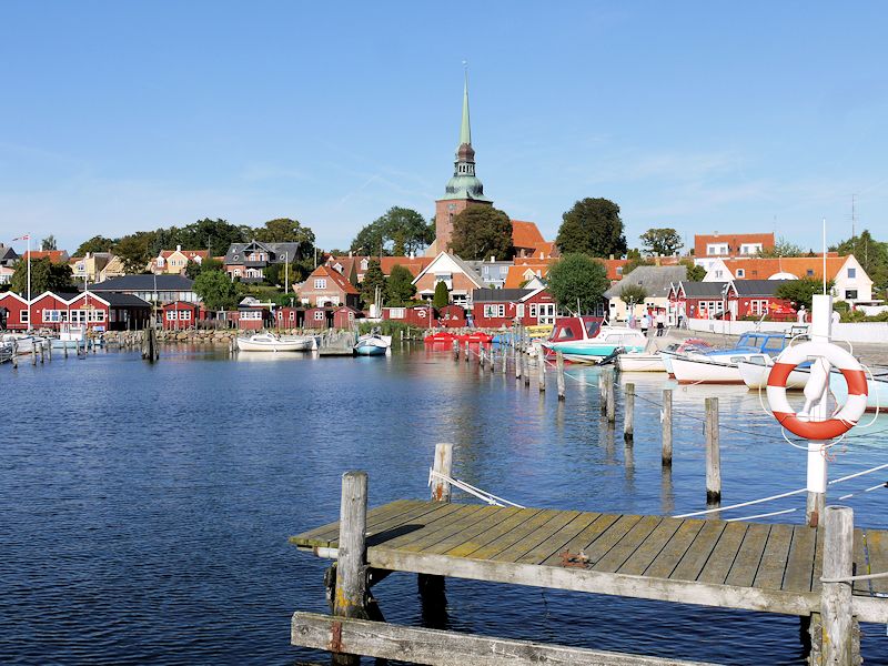
Kalvehave harbour with the Queen Alexandrine Bridge to the island of Møn in the background
There are a number of islands in the waters off Møn, including Nyord and Bogø, the smaller island of Farø, as well as the islands of Langø, Tærø and Lilleø off the coast of Zealand. The island of Lindholm in Stege Bugt is state-owned, and is the location for the State Veterinary Institute for Virus Research (Statens Veterinære Institut for Virusforskning).
Transport
Møn is connected to Zealand at the town of Kalvehave by the Queen Alexandrine Bridge. The bridge opened for traffic on May 30, 1943, and is named after Queen Alexandrine, the Queen Consort of King Christian X. The bridge is 746 metres (2,448 ft) long and considered to be one of Denmark's most attractive bridges.
At the south-western corner, Møn disconnects by causeway to the 5 km × 7 km (3 mi × 4 mi) island of Bogø. From Bogø another causeway connects to the small island of Farø, which acts as the centre point for the Farø Bridges carrying the motorway between Zealand and Falster. The north Farø bridge has a span of 1.5 km (1 mi), the south bridge a span of 1.7 km (1 mi) with a 290-metre-long (950 ft) central span for shipping. The central span is supported by cables from two 95 m (312 ft) pylons which raise the bridge 26 metres (85 ft) above sea level. The bridge was completed in 1984 and forms part of Euroroute E47 from Copenhagen (and Helsingborg) to Lübeck (and thence Hamburg and the south).
At the north-western tip of Møn there is a narrow bridge to the small island of Nyord.
Attractions
Møn is known for its natural beauty, sandy beaches, fresco-decorated churches, Stone Age and Bronze Age passage graves and monuments, and Møns Klint ("The White Cliffs of Møn"), the island's most popular attraction.
The cliffs, c. 6 km long and up to 128 metres tall, are Denmark's highest, and support a unique set of natural habitats. Access to the narrow beach is via a flight of 500 steps from the parking area set within the beech forest behind the cliffs. The GeoCenter Møns Klint, a geological museum tracing the origins of Denmark and the formation of the cliffs opened there in May 2007. The combination of chalk in the subsoil with a dry local climate, and its agricultural use consisting primarily of cattle grazing, has created some of Denmark's richest meadowlands. The chalk was transported to Møn during the fourth, and most recent, major ice age.
Another attraction close to the cliffs is Liselund, the romantic summer residence erected in the 1790s by French nobleman Antoine de Bosc de la Calmette for his wife, Lise. The miniature thatched palace and grounds were designed by Andreas Kirkerup, one of the foremost landscape architects of the times. A larger house was constructed in the park in 1887 by Baron Fritz Rosenkrantz, which is now a hotel. The park is open to the public and includes the original thatched manor house, Swiss cottage, Chinese tea house and Norwegian log cabin. Calmette was also responsible for the park at Marienborg, to the west of Stege.
At the north-western corner of Møn is a narrow bridge to the island of Nyord. The small village on the island has a number of quaint cottages and farmhouses as well as a unique octagonal church and a small harbour. Nyord is an important habitat for geese, ducks and other wading birds. There is a bird-watching tower for the use of visitors.
At the south-western corner, Møn connects by causeway to the 5 by 7 km island of Bogø. The island has a preserved windmill, an old bording school and a summer ferry to Stubbekøbing.
Møn has a number of interesting churches decorated with frescos. Fanefjord Church dates back to the 13th century, and has a set of recently restored frescos painted in 1450 by the Elmelunde Master. Frescos can also be seen in Elmelunde Church, the oldest church on the island, with parts dating from the start of the 12th century. Keldby Church has a unique altarpiece and is also richly decorated with frescos. Another interesting church is the one at Damsholte. It is one of the finest Rococo buildings in Denmark and the only village church built in the Rococo style.
The oldest and perhaps most impressive burial mound on Møn is Grønsalen near Fanefjord Church. The 100 m by 10 m barrow is from around 3500 BC. According to legend, it is the resting place of Chief Grønjæger (Greenranger) and his wife Queen Fane, after whom Grønsund and Fanefjord were named. There are also barrows at Raaby and Busemarke. There is also a 5,000-year-old round burial barrow at Sømarke, and others at Jættestue and Jordehøj. Kong Asgers Høj at Sprove is the largest gallery grave in Denmark, more than 4,000 years old. It has been fully excavated and can be visited inside. There is another round barrow at nearby Rundysse, and a further recently restored 9 metre long double passage gallery grave at Klekkende Høj from the Neolithic age c. 4,500 years old.
Thorsvang, Danmarks Samlermuseum is a museum of collectables arranged in a number of old shops typical of the early 20th century. It is located in the Lendemarke district of Stege.
There is a jewellery museum in the little village of Damme and near Keldbylille, there is a museum (Museumsgaarden) depicting life on a Møn farm as it was 100 years ago. There are also several art galleries and arts and crafts centres on the island.
Møn also has a number of popular beach resorts, particularly in East Møn with Ulvshale to the north and Råbylille Strand, Klintholm Havn and Hårbølle on the south side of the island.
Economy
Tourism plays an important role in the local economy. One of the largest employers is Bisca, a manufacturer of cakes and biscuits headquartered in Stege. Møns Bank traces its history back to 1877. About one third of its customers live on the island. The old town hall in Stege was converted into a centre for entrepreneurship in 2008 and is now home to some 10 start-ups.
FANØ
Fanø is a Danish island in the North Sea off the coast of southwestern Denmark, and is the very northernmost of the Danish Wadden Sea Islands. Fanø municipality is the municipality (Danish, kommune) that covers the island and its seat is the town of Nordby.
Island
Fanø is separated from the mainland by the Wadden Sea over a span of approximately five kilometres (3.1 miles). The island is 16 kilometres (9.9 miles) long and 5 kilometres (3.1 miles) wide, and it is located off the coast from the city of Esbjerg to which it is connected by ferry. The ferry ride takes 12 minutes. The high ferry ticket prices that are often subject to price increases are considered by the locals to be a great threat to the local tourism industry.
A variety of environments are to be found on Fanø. Not surprisingly, a very common one is sand. The island's whole western shore is one long beach. The island's northwestern corner is a vast sandbank called "Søren Jessens Sand". Søren Jessen was an entrepreneur and captain from Hjerting, today the westernmost suburb of Esbjerg and the bank is named after him because his ship, the "Anne Catriane", stranded here in 1712.
The vegetation on Fanø is mainly heath and small pine trees, never growing tall because of the predominant strong westerly winds from the North Sea.
Fanø relies heavily on tourism and is visited by some 30,000 people each summer. The main attraction is the fine white sand beach, which is also a popular playground for all kinds of wind and water sports, such as kite flying, surfing and buggies. Fanø also hosts Denmark's first golf course, Fanø Golf Links, established in 1901.
Long before paved roads, the beach - being long, straight and quite firm - hosted a yearly motorcycle and car racing event from 1919 and until 1923, where a tragic accident killed a local boy and put a stop to further events. Today is possible to drive your own car on the beach all the way from Sønderho to Fanø Vesterhavsbad. A public bus service is also operated on the beach.
Also unique is the Wadden Sea with seals and migrating birds, as well as the two sailor towns Nordby and Sønderho with their maritime history, once among the most wealthy and influential in Denmark, and their vernacular architecture consisting of thatched-roof houses all oriented west-east, again because of the westerly winds.
During World War II, Fanø was part of the Atlantic Wall and the remains of the 300 bunkers built by the Nazis can still be spotted along the coast line.
AMAGER

Amager or, especially among older speakers, is a Danish island in the Øresund. The Danish capital, Copenhagen, is partly situated on Amager, which is connected to the much larger island of Zealand by five bridges. Amager also has a connection across the Øresund to Sweden, the Øresund Bridge. Its western part begins with a tunnel from Amager to another Danish island, Peberholm. Copenhagen Airport is located on the island, around 7 km (4 mi) from Copenhagen city centre. Amager is the largest island in the Øresund, and the only one with a large population. As of 2016, 192,709 people live on the island, including its northern tip, Christianshavn. The northern part is included in the Copenhagen municipality. The middle part comprises Tårnby municipality, and Dragør municipality is located on the southeast part of the island. Most of the western part is land that was reclaimed from the sea from the 1930s-1950s. This enlargement, from the shallow sound towards Zealand, is known as Kalveboderne. The enlargement has never been built-up and its soil isn't suitable for agricultural use. However the area between Dragør town and the airport is cultivated land of high quality. Amager has in the past been referred to as the "kitchen of Copenhagen". At the border of the enlargement there is an old beech forest, Kongelunden (The King's Grove).
A number of animals that are otherwise common in Denmark, such as vipers, squirrels, moles, rats and badgers, are nonexistent on the island, whereas foxes, hedgehogs, roebucks, hares and especially rabbits exist in abundance.
Municipality
The municipality is in Region of Southern Denmark, and covers an area of 56 square kilometres (22 square miles). It has a total population of 3,192 (2008). Its mayor is Erik Nørreby, a member of the Venstre political party.
The main town and the site of its municipal council is the town of Nordby. Other towns include Sønderho, Fanø Vesterhavsbad and Rindby.
Fanø municipality was not merged with other municipalities by January 1, 2007, despite the nationwide Kommunalreformen ("The Municipal Reform" of 2007).
History
Amager has long been populated, and well used, thanks to its rich soil and proximity to Copenhagen. In 1521, Christian II invited some Dutch farmers to move to Amager and grow vegetables to supply the Danish Court and Copenhagen. It was only in the late 19th century that Copenhagen began to expand onto the island (Sundbyerne), and in 1902 these built-up areas were incorporated into Copenhagen.
During the Second World War, high unemployment in Copenhagen led authorities to drain a large part of the sea, west of the island, and build a dam to hold out the water, effectively adding one half of Amager's previous area to the island.
The reclaimed area is currently known as Kalvebod Fælled, and was originally a military area, but today it is part of a major construction area called the Ørestad, being thought of as an extension to central Copenhagen. The area houses such major facilities as the Bella Center, a convention and exposition center, and Field's, the second-largest shopping center in Scandinavia. This project was initiated by the Danish government.
The beach area to the east of the island, known as Amager Strandpark (Amager Beach Park), which had fallen into disrepair since its inception in the 1930s, was extensively redeveloped between May 2004 and August 2005. A 2-km-long artificial island, Peberholm, was constructed just off the mainland. Peberholm has a small lagoon. It was named Peberholm (Pepper Islet) because it lies just south of Saltholm (Salt Islet), an island nature reserve that has only two (2) inhabitants (1 January 2016) and is part of Tårnby Municipality.
During the 1970s, Amager was used as a place to dump litter; this led to a slang term for the island 'Lorteøen' (Shit Island). See Renholdningsselskabet af 1898.
Amenities
Large parts of Kalvebod Fælled are rich in nature and have many grazing cows and horses. This area allows the citizens of Copenhagen to experience nature, without travelling far from the city.
The seaward-facing side of the island has a wide sandy bathing beach, while the lagoon-facing side is mainly made up of low dunes. There is another beach on the mainland side of the lagoon, which runs alongside the beach road. Ice-cream kiosks, coffee shops, a marina and two small recreational parks can also be found in the Strandpark area. The lagoon is popular, and regularly used, for water sports such as kayaking or wind-surfing.
Amager is also home to the Amager Bio, a cinema, concert and cultural venue. Top bands from the last 40 years have played there, both those of international origin (Prince, Aimee Mann, Uriah Heep, King Crimson, Cradle of Filth, John Mayall and the Bluesbreakers, Jethro Tull, The Moody Blues, MGMT, Nas, Andrew Bird) and from Denmark (D.A.D, Dodo and the Dodos, Johnny Deluxe, Big Fat Snake).
Communities
Various communities are located on Amager, including Islands Brygge, and the towns of Dragør, Kastrup, and Tårnby.
Transport
The Øresund Bridge connects Sweden to Denmark at Amager. The construction of the bridge has had a significant impact on the physical geography of the island, largely due to the construction of new highways.
The Copenhagen Metro connects Amager to central Copenhagen. The metro line from Vanløse to Amager divides into M1 and M2 lines at Christianshavn and then continue to Vestamager and Lufthavnen (Copenhagen Airport).
Copenhagen Airport is in the eastern part of Amager. It is linked by train, metro and bus services.
FAROE ISLANDS

The Faroe Islands, are an archipelago between the Norwegian Sea and the North Atlantic Ocean, approximately halfway between Norway and Iceland, 320 kilometres (200 miles) north-northwest of mainland Scotland. The area is approximately 1,400 square kilometres (541 square miles) with a 2015 population of 48,700. The islands are an autonomous country within the Kingdom of Denmark.
The land is rugged and has a subpolar oceanic climate: windy, wet, cloudy and cool. Despite its northerly latitude, temperatures average above freezing throughout the year due to the Gulf Stream.
Between 1035 and 1814, the Faroe Islands were part of the Kingdom of Norway. The 1814 Treaty of Kiel granted Denmark control over the islands, along with two other Norwegian regions: Greenland and Iceland. The Faroe Islands have been a self-governing country within the Kingdom of Denmark since 1948. The Faroese have control of most domestic matters; areas that remain the responsibility of Denmark include military defence, police, justice, currency and foreign affairs. However, as they are not part of the same customs area as Denmark, the Faroe Islands have an independent trade policy and can establish trade agreements with other states. The islands also have representation in the Nordic Council as members of the Danish delegation. The Faroe Islands also compete with an individual team in certain
Geography
The Faroe Islands are an island group consisting of 18 major islands about 655 kilometres (407 mi) off the coast of Northern Europe, between the Norwegian Sea and the North Atlantic Ocean, about halfway between Iceland and Norway, the closest neighbours being the Northern and Western Isles of Scotland. Its coordinates are 62°00′N 06°47′W.
Climate
The climate is classed as subpolar oceanic climate according to the Köppen climate classification: Cfc, with areas having a tundra climate, especially in the mountains, although some coastal or low-lying areas can have very mild-winter versions of a tundra climate. The overall character of the islands' climate is influenced by the strong warming influence of the Atlantic Ocean, which produces the North Atlantic Current. This, together with the remoteness of any source of warm airflows, ensures that winters are mild (mean temperature 3.0 to 4.0 °C or 37 to 39 °F) while summers are cool (mean temperature 9.5 to 10.5 °C or 49 to 51 °F). In 2012 the mean temperature of January was 4.5 °C (40.1 °F), in July the mean temperature was 10.1 °C (50.1 °F) and all that year it was 6.7 °C (44.1 °F). In 2012 the capital of the Faroe Islands, Tórshavn, had 195 days with precipitation and received a total of 1,262 millimetres (50 in) that year. In 2012 there were at total of 32 frost days and a total of 1032 hours with bright sunshine. The mean wind speed m/s that year was 6.8 m/s The islands are windy, cloudy and cool throughout the year with over 260 annual rainy days. The islands lie in the path of depressions moving northeast and this means that strong winds and heavy rain are possible at all times of the year. Sunny days are rare and overcast days are common. Hurricane Faith struck the Faroe Islands on 5 September 1966 with sustained winds over 100 mph (160 km/h) and only then did the storm cease to be a tropical system.
Relationship with Denmark
The Faroe Islands have been under Danish control since 1388. The 1814 Treaty of Kiel terminated the Danish-Norwegian union, and Norway came under the rule of the King of Sweden, while the Faroe Islands, Iceland, and Greenland remained Danish possessions. The Løgting was abolished in 1816, and the Faroe Islands were to be governed as an ordinary Danish amt (county), with the Amtmand as its head of government. In 1851, the Løgting was reinstated, but, until 1948, served mainly as an advisory body.
The islands are home to a notable independence movement that has seen an increase in popularity within recent decades. At the end of World War II, some of the population favoured independence from Denmark, and on 14 September 1946 an independence referendum was held on the question of secession. It was a consultative referendum; the parliament was not bound to follow the people's vote. This was the first time that the Faroese people had been asked whether they favoured independence or wanted to continue within the Danish kingdom.
DENMARK'S BEST BEACHES
Denmark has some of the most beautiful beaches in Europe. With over 7,300km of coastline, choosing the best of Denmark's fine white sand, family friendly and crowd-free beaches is tough! We've picked some of Denmark's most popular beaches for this guide, bringing together dynamic dune-covered beaches and calm, sheltered beaches great for kids. What's more, you're never more than 50km from the coast in Denmark, which means a day at the seaside is easy. Find your perfect beach in Denmark here:
SØNDERVIG BEACH

Søndervig has been one of the most popular Danish seaside resorts since the 19th century; especially because of its wide and white sand beach.In 2014, Danes voted Søndervig Beach in West Jutland as Denmark's best beach. A popular seaside resort for the last century, Søndervig is a dynamic beach backed by rolling sand dunes on the North Sea.
Søndervig is one of the most popular holiday destinations by the North Sea; with its location right on the coastline, close to the fjord, and in the midst of the uniquedune landscape there is every chance to have a great vacation here. In addition to Søndervig’s beautiful scenery, the town also offers shopping, restaurants, cafés, and fun activities for kids at all hours of the day.
The beaches at Søndervig are some of the best on the Danish west coast and each year they attract scores of water loving tourists. This cosy beach resort, which is situated between the North Sea and Ringkøbing Fjord, offers a wide selection of accommodations: holiday homes on the seafront, homely bed & breakfasts, holiday apartments, and a campsite; here you can easily find what accommodates your needs.
In Søndervig there is a newly constructed ‘terrain path’ which provides excellent access for baby carriages and wheelchairs. Lifeguards on the beach from 20.6. – 13.8 - 2016.
AMAGER BEACH PARK
Copenhagen has its own beach park! 5 kilometres of sandy beach and outdoor activities on an island and lagoon. It's as popular with families as it is with young locals, due to its calm waters and open spaces. Get here by metro from the city centre.
Copenhagen's beach area, Amager Beach Park is busy all day long in the summer, and there is no doubt that it is one of the best spots to spend the long Copenhagen summer days and bright evenings.
The beach park consists of a two km long artificial island forming a lagoon with toddlers' pools on the one side, and a big sandy beach with dunes on the other. The southern part of the park has a broad promenade and areas for different ball play and picknicking
From the beach you have a spectacular view to a windmill park and the impressive bridge Øresundsbroen connecting Denmark and Sweden.
The beach park is a popular place both for sunbathing and relaxation as well as for all kinds of sports and activities. You will meet runners, skaters, surfers swimmers and kayakers and many more enjoying the beach parks’s many facillities.
All year, and especially during the summer, lots of different activities take place here such as sports events of all kind, rock concerts and open air weddings.
Please see Amager Beach Park's own website for more information.
TISVILDELEJE BEACH

Tisvildeleje Beach at the top of the Danish Riviera on North Zealand, is a popular holiday area for Danes. Visit the quaint fishing town of Tisvildeleje or rent a summer house and walk the picturesque heathland of Tisvilde Hegn nearby.
Lovely child friendly sandy beach with clean water and lifeguard in high season. You can park near the beach and the train station is only approx. 1 kilometer away.
There is a building with kiosk and restrooms in between the two lifeguard items.
There is disabled parking and beach access for wheelchair users at the pier / bay furthest to the east. By the kiosk, there is a toilet for disabled.
KERTEMINDE NORTH BEACH

Kerteminde's North Beach on Funen Island is popular with families and young people. There's always life and a fun atmosphere here throughout the summer months. Only a few hours' drive from Copenhagen and close by Odense.
Nordstranden is the most popular beach in Kerteminde. People from far and near flock to the beach to enjoy the fresh seawater from Storebælt. The beach is primary sand, while the beach further up towards the Hindsholmvej, with the beautiful villas, the vegetation is grass and beach rush.
Nordstranden is a distinct sand beach with many sandbanks. It means, that it is possible to get far from the shore before it gets really deep. Of the same reason the beach is very child friendly.
Nordstranden has the Blue Flag Programme
About midway on the beach there is placed a parking place and a kiosk with the possibility of buying various refreshments. At the south part of the beach there is a minigolf course. Furthermore there is a bathing jetty, beach volley- and handball pitch’s and of course toilets.
Moreover in the peak season there are lifeguards from the Tryg Foundation.
Distance to Centrum: 0,2 – 2 kilometres.
Driving directions from Kerteminde Turistbureau:
Follow Hans Schacksvej towards the harbour and turn left at the traffic light onto Hindsholmvej. Continue at Hindsholmvej until you reach the parking place on your right hand.
HESTEHOVED BEACH
 Hestehoved Beach, on the island of Lolland, has beautiful clean waters and one of the longest bathing jetties in Denmark. Head to the beach right next to the recreational area along Nakskov Fjord and close to the market town of Nakskov.
Hestehoved Beach - The Blue Flag 2010, 2013 & 2014 - The bathing jetty is the second longest in Denmark – handicapped access An artificial sandy beach constructed in a beautifull recreational area out on Nakskov Fjord and close to the market town of Nakskov.
Restaurant Fjorden, Nakskov Fjord Camping and Hestehoved Marina offer numerous possibilities for leisure activities including beach volleyball and crazy golf. The shallow waters along the sandy beach afford safe bathing for families with small children and the spectacular 190 metre long bathing jetty ensures that you can also come to the deeper water.
There are bus connections to the market town Nakskov. The area where the beach is situated is a Natura 2000 protected area due to the diverse birdlife around Nakskov Fjord. You should therefore take due consideration to nature when using the beach. Dogs should be kept on a leash from 1st of April to 30th September. www.nakskovfjord.dk
”Nakskov Fjord days” the first weekend in september: a wealth of exciting activities in and around Nakskov Fjord.
Tour of Nakskov Fjord onboard the Mail boat, meeting point: Nakskov Harbour, contact the tourist bureau, tel. +45 54 92 21 72 for a reservation.
During the bathing season, the beach is cleaned every third week by the Nakskov Idrætsmærkeforening (sports association).
There is handicapped access, a bathing jetty, and tables with benches at the location as well as car parking at the camping site, where you will also find a kiosk and toilets.
MARIELYST BEACH

Stretch out on Denmark's best beach three years in a row! Marielyst Beach on the island of Falster in South Zealand is a laid-back, child-friendly beach with calm waters and several sandbanks to explore.
Picturesque beach, where you can build sandcastles and collect shells. Moreover, there are cliffs, which afford excellent shelter. The beach has Blue Flag status. The quality of the bathing water is ensured by amongst others not discharging wastewater from the eastern side of South Falster.
The lifeguard tower is open every day 11.00-19.00 from 30/6 to 23/8.
The lifeguards deploy the following coloured flags:
- Half red, half yellow: Recommended bathing area patrolled by a lifeguard.
- Yellow: Exercise due caution.
- Red: Danger, unsafe for bathing!